by Sue Ding
In 2004, yellow arrow stickers began appearing in cities around the world. In Berlin, they pointed to shuttered but not forgotten nightclubs. In Washington, D.C., they invited people to tour landmarks from the 80s punk rock scene. At Art Basel in Miami, the arrows presented a “counter exhibition” democratically curating the city, and alongside the Copenhagen harbor, they hosted conversations between mayoral candidates and their constituents. In Tokyo, they recommended ramen spots; in Mexico City, they described architectural history and highlights. In nearly 40 countries around the world, the arrows shared personal stories, encouraged lively discussions, and offered new perspectives on urban environments.
The geo-annotation project Yellow Arrow, by Christopher Allen, Brian House, and Jesse Shapins, ran from 2004 to 2006, beginning in Manhattan’s Lower East Side and spreading across the globe. It was conceptualized as “fundamentally a new way of exploring cities […] a frame and platform to see the world in a new way.”1 Participants posted Yellow Arrow stickers in order to point out or comment on specific locations and objects. Each sticker featured a unique alphanumeric code, and by texting the Yellow Arrow phone number using this code, users were able to attach a short message to the location where they had posted the sticker. Subsequent passers-by could text the Yellow Arrow number with this same code and receive the saved message in response. They could also reply via text message to the original author. Over the course of the project, participants posted more than 50,000 arrows and messages.2 Yellow Arrow was both fundamentally participatory and profoundly location-based: “We called it a MAAP, a Massively Authored Artistic Publication, and then obviously also made it in a form of a map,” says co-creator Christopher Allen. This early example of mobile location-based media illustrates the creative potential of more open, collaborative models of authorship. It also highlights how location-based media and annotation can be used to explore alternative uses and narratives of space.
Implementation and Usage
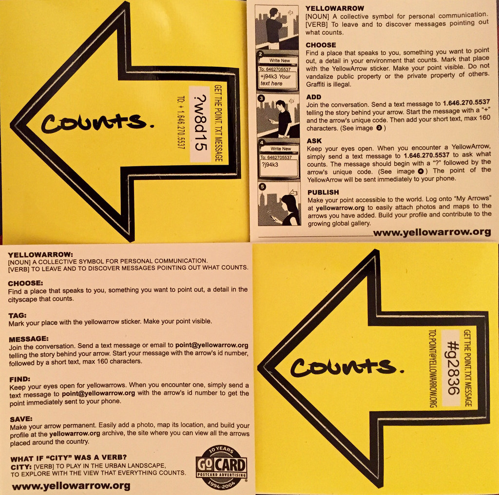
Yellow Arrow stickers and instructions.
Yellow Arrow was designed to be as accessible as possible. To begin with, it was based on the “lowest common denominator” technologies of text messages and stickers (spray paint, chalk, and permanent marker are even more affordable modes of annotation, of course, but lack the networked interaction capabilities of text messaging). The stickers were distributed for free at specific venues and events, or you could purchase them for 50 cents. All the messages were also available on the project website, searchable by location or by username. In this way, the creators hoped to democratize the mapping of the city, allowing anyone to map their subjective experiences onto the physical environment.
People used the platform in many different ways, from sharing political views to posting poetry fragments, and many local projects focused on specific topics like architecture or environmental issues. Other people used the stickers simply for decoration, or attempted to employ them for marketing and promotional purposes. Many participants only authored one arrow, likely treating the process as a novelty, while other individuals became “super users,” according to Christopher Allen, posting arrows daily and “almost treating it like they were photographers and were looking for their next shot.” While this intensive usage was often a more individual practice, the platform also facilitated interactions between users. Many arrows took the form of prompts, instructions or questions that invited, and received, direct responses. People could respond via texting, or through the project website. Participant phone numbers were not published, but messages included their author’s Yellow Arrow username, or “tag name.” It was thus possible to directly respond to authors through the Yellow Arrow phone number, using either their tag name or the code on the arrow they had posted. All posts and responses were logged as entries in the Yellow Arrow database, along with location, username, and arrow code metadata.

Yellow Arrow sticker in San Francisco, CA.
Partly due to favorable early press from a few high profile outlets, the project rapidly spread out geographically from its origins in New York City, with usage most concentrated in a few major cities. The creators found that organizing events, or collaborating with people and groups interested in hosting their own events, was the most effective way to reach potential users. Working with existing organizations and groups provided built-in distribution and communication channels, and event-specific instantiations of the project could appeal to participants by focusing on topics and themes of interest. Furthermore, word of mouth spread easily with people occupying the same venues, and the geographic concentration of people led to relatively dense (and therefore conspicuous) posting of stickers. Co-creator Christopher Allen notes, though, that the project rarely achieved a level of density where someone would be able to follow arrows from block to block consistently. The project’s wide (and rapid) geographic dispersal precluded that kind of density, whereas limiting Yellow Arrow to one neighborhood in one city would have led to very different results. For participatory location-based works, choices about scale and (desired) density are both difficult and critical; these decisions influence the embodied experience of the work, as well as modes of participation.
Challenges
Yellow Arrow also prefigured other challenges involved with producing digital location-based works, including the archiving of projects. The Yellow Arrow website is now defunct, although much of the content is archived on Flickr (4,500 photos of arrows, and their corresponding messages and comments). While the Flickr archive is sizeable, it offers a clumsy interface for viewing the arrows, and it is subject to Flickr’s shifting policies and ownership. Of course, the alternative—maintaining the original Yellow Arrow website—might present problems of its own, including cost and the necessity of updating code from 2006. The struggle against obsolescence—keeping abreast of evolving technologies and updating projects on unstable platforms—is still daunting for today’s digital creators.
Yellow Arrow also occupied an uneasy space between the conceptual art world and the tech world. Christopher Allen recalls:
We were trying to do a piece of conceptual art. At the same time, it was obviously engaged with new technologies and it represented, for a lot of people, potential business models or practical possibilities. We got pulled in a lot of ways towards start-up culture, so we were in between these worlds […] there were some mixed messages for the project as a whole, and we were trying to satisfy a lot of different viewpoints.
This struggle was in many ways a harbinger of the current landscape for location-based media, and the difficulty creators face in navigating disparate industries, disciplines, and communities of practice.
Annotation
Yellow Arrow exemplifies one of the major categories of location-based media, that of annotation. To annotate is “to make or furnish critical or explanatory notes or comment.” While annotation is an important concept in many domains, what is relevant for location-based media is spatial annotation, or geo-annotation. Geo-annotation involves assigning media to specific physical locations, to be consumed at these same locations. Buildings, streets, and cities have long been surfaces inscribed with information, memories, and meaning. Graffiti, marble plinths, government notices, promotional posters, and commemorative plaques both provide information about, and help to shape, their environments and the activities that occur within them. Annotation is an essential mechanism for spatial narrative, documentation, and augmentation.

Yellow Arrow sticker in Cambridge, MA.
Annotation is also a powerful tool for shaping discourse, based on what is annotated in the first place, who the annotation is intended for, and how the content of the annotation is conceptualized. Even something as seemingly neutral as street signs can be symbolically weighted. Scholar Priscilla Parkhurst Ferguson notes, “For centuries, most villages and towns felt no need to name their streets, and even today a major urban center like Tokyo manages to do without them.”3 She writes that the naming and labeling of streets is a key mode of reinforcing and contesting control, shaping identity and culture, and mediating between individuals, institutions, and the state. In 18th-century Paris, for example, street names functioned as a way to exert and signify royal power, a form of “symbolic eminent domain.”4 At the same time, annotation inherently supports diverse, abundant, and competing messages, and offers a dynamic forum for public discourse and debate. Cited as inspiration by the Yellow Arrow creators, Jean Baudrillard wrote of the May 1968 student strikes in France:
The real revolutionary media were the walls and their speech, the silk-screen posters and the handpainted notices, the street where speech began and was exchanged – everything that was an immediate inscription, given and turned, spoken and answered, mobile in the same space and time, reciprocal and antagonistic. The street is, in this sense, the alternative and subversive form of the mass media, since it isn’t, like the latter, an objectified support for answerless messages, a transmission system at a distance. It is the frayed space of the symbolic exchange of speech – ephemeral, mortal.5
Spatial Hypertext and Tagging
Networked locative technologies add a new dimension to annotation, rendering the world a spatial hypertext linking physical locations and virtual content. This ability to digitally overlay information and inscribe narrative on physical space allowed Yellow Arrow (and other similar projects) to become a collectively authored document of subjective experiences between the physical and the virtual. Many have noted the significance of this development, describing it as the “geospatial web,” “reality browser,”6 “hypertextual universe,” and “real-world websurfing.” In Headmap Manifesto, Ben Russell predicted that with the advent of locative and mobile technologies, “The whole world will become an annotated space, which links from the real to the information space and back again. The world as interface.”7 This connection of the physical world to networked virtual worlds, according to Jillian Hamilton, emphasizes the importance of sense of place and “provides an alternative to the assumption that digital content is placeless,” as exemplified by the term “cyberspace.”8
Many artists and creative technologists were interested in exploring these new possibilities, and a number of notable geo-annotation projects appeared around the same time as Yellow Arrow, including Urban Tapestries (2002-4), (area)code (2004), Murmur (2003), and Grafedia (2004). Like Yellow Arrow, these projects used mobile phones (or PDAs) and text messaging to link digital content with physical locations, invited participants to share their experiences of a place, and explored the affordances of new locative technologies. Another similar project, Semapedia (2005), generated QR codes for Wikipedia entries, allowing people to print them out and post them on or around corresponding physical locations. Among this generation of projects, Yellow Arrow is particularly interesting because of its scale, and because of the diversity of its usage—not only the different types of user content and interactions it supported, but also the different thematic instantiations of the work.
Yellow Arrow is also notable for the way it drew on the appeal and interaction modality of physical tagging. Architecture scholar Malcolm Mcullough writes about annotation through the lens of tagging:
There is no simpler piece of situated technology. Although overtly semantic itself, a tag quickly shifts attention to the intrinsic structure of whatever it labels. Tags are simpler and possibly more prevalent than screens, which are the assumed focus in today’s economics of attention. Whereas the contents of a screen are disembodied and usually disengaged from context, a tag is almost always about something right here. More basically still, a tag is physically inscribed and not sent.9
Tagging is most commonly associated with graffiti, acting as a boasting system and mode of marking territory. However, new technologies have facilitated new forms of tagging, including programmable LED lights, wearables, and GPS-enabled mobile applications. Mcullough also notes the evolution of the tag as a key mechanism for organizing and identifying digital content, from SEO-friendly keywords to Twitter hashtags; the tag as metadata is another mode of contextualizing and providing information. Yellow Arrow successfully combined the somewhat rebellious attraction of physical tagging with the conceptual and functional roles of metadata.
Annotation and Augmented Reality
Annotation is information that overlays and augments the physical world, and as such, it is an important framework for augmented reality. Of AR, Malcom Mcullough says, “The basic idea is certainly one of tagging.” He notes the early mobile geo-annotation apps and AR platforms Layar and Wikitude; these apps also reflect AR’s intrinsic connection to place, imitating “more conventional guidebook technologies” in providing information about historical landmarks and local attractions. Thinking about AR as annotation allows us to reflect on questions of attention and how technology facilitates our interactions with place. Many proposed industry applications of AR tend toward gaudy and distracting visual interfaces and content. A great deal of spatial annotation can also be described this way (e.g. neon signs and flashing electronic billboards), but its overwhelming abundance demands consideration of how attention operates in space. Over the course of its long history, spatial annotation and visual attention have been extensively studied in fields like architecture, urban planning, mapping, and graphic, retail, and exhibit design; AR developers would do well to draw on the deep expertise in these fields to better understand the visual attention economy AR operates within.
Approaching AR as annotation also invites consideration of attention modalities outside of the current industry paradigm of head-mounted displays, which treat screen-mediated selective visual gaze as the sole, or primary, mode of attention. The creators of Yellow Arrow sought to augment the city without distracting from it: “The limitations of text-messaging (no images, no sounds, only 140 characters) allow the visual and sonic environment of the city to take precedence.”10 Users are encouraged to interact with their mobile phones only minimally, navigating primarily with their bodies through the interface represented by the physical environment around them.
Protocol (vs. Narrative)
Yellow Arrow exemplifies a mode of storytelling that could be more readily described as a protocol than a narrative in the traditional sense. Co-creator Jesse Shapins describes it thusly:
Yellow Arrow’s authorial structure models conventions of software development more so than traditional artistic practice. In effect, Yellow Arrow is a software application with a fixed feature set. Any user with the appropriate technology can use the software within the constraints we set up.11
While Shapins and his Yellow Arrow co-creators defined the “software’s” features and restrictions, users were free to use the software as they saw fit. Yellow Arrow separated the authors of the platform from the authors of the content, and allowed users the freedom to communicate directly with each other and create their own themes and communities of use (although they could not set up independent projects within the platform). Co-creator Christopher Allen says of this model, “We really thought of them as authors and artists, more than users.” This emphasis on contributory content, and high degree of user agency, resulted the diverse range of uses described in preceding sections.
Happenings and Participation
Yellow Arrow’s open narrative structure and conceptual framework reflect precedents in avant-garde art, including Dada events at Hugo Ball’s Cabaret Voltaire, Surrealist theater, interdisciplinary performances at Black Mountain College, and the happenings of the late 1950s and 1960s. American artist Allan Kaprow coined the term “happening” to describe a type of participatory event that blurred the boundary between art and life, between performance and the everyday. Members of the audience were conceptualized as active, and essential, participants in the work. In fact, Kaprow wrote, “audiences should be eliminated entirely,” through their full integration into the performance.12
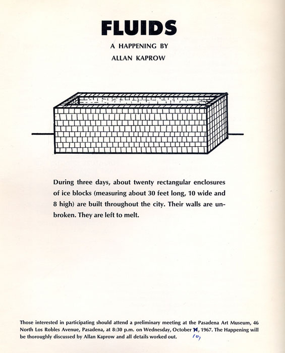
Poster for Fluids, a happening by Allan Kaprow, 1967.
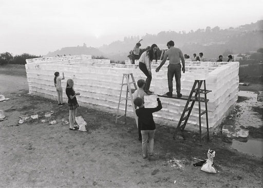
Fluids by Allan Kaprow, photographed by Dennis Hopper, Beverly Hills, October 1963.
Happenings reflect many of the key affordances, both formal and conceptual, of participatory location-based media. Their creators sought to bring art outside of galleries and theaters, and beyond the singular, delimited time of conventional performances—to make art in the real world, and in real time. In “How to Make a Happening,” Kaprow wrote:
Break up your spaces. A single enactment space is what the theatre traditionally uses. You can experiment by gradually widening the distances between your events, first at a number of points along a heavily trafficked avenue, […] then on more than one street, then in different but nearby cities, finally all around the world.13
For Kaprow and other artists creating happenings, the world was the stage, and the performance built on real-world locations, situations, and interactions, both planned and unplanned. Beginning with a short list of scenarios, images, and instructions, participants (largely non-professionals) interacted with both each other and their environment to create the happenings.
Many participatory location-based projects, including Yellow Arrow, share a similar authorship model with the happening. Creators establish a protocol, or in the case of Kaprow’s happenings, a “program”—a term that clearly derives from the happening’s theater performance roots, but in which we can now also identify a connection to the software development use of the term. Participants are then given a high degree of agency in operating within, and interpreting, this rule set in order to realize an improvisatory and multi-voiced work. This creative act of interpretation is a crucial aspect of many location-based works, helping to transform places into active and meaningful spaces, and presenting enormous potential for narrative, affective, and political intervention.
Alternative Uses and Experiences of Public Space
These projects also share a goal of creating a heightened experience of the everyday. They invite actions—whether wrapping yourself in tinfoil or licking jam off a car, as in some of Kaprow’s works, or annotating a building with a sticker and a story—that resist functional, officially approved uses of space. In doing so, they offer people an opportunity to call into question the daily routines, social norms, and often hidden dictates shaping our movements, encounters, and actions in public space. This emphasis on alternative uses, narratives, and experiences of public space is central to Yellow Arrow. Christopher Allen says the goal of the project was to document people’s lived experience of place—to prioritize the everyday and the personal rather than official landmarks and attractions. Jesse Shapins also notes the project’s indebtedness to the Situationists, “in particular, their emphasis on critiquing the presumed objectivity of the map, and instigating play and experimentation in the physical environment.” Some local projects explicitly engaged with Yellow Arrow’s more critical aims: Guerilla Geography, in the UK, invited participants to post stickers on CCTV surveillance cameras, prompting them with questions like “How does CCTV change your personal, private social, emotional, party, peace or love space?” Other groups focused on climate change, debates about urban revitalization, and bikers’ rights.
Annotation, as a mode of collective authoring, also generates new social connections between participants, as well as new individual relationships to place. Annotation of public spaces provokes conversation and debate between both users and observers, often carrying discourse across conventional socio-economic divisions. It can profoundly reinforce or transform a community’s understanding of itself, while also creating new social bonds among a community of practice. Annotation is often necessarily brief (for reasons of cost, convenience, or risk), and epigrapher Bradley McClean notes that it “tend[s] to omit pertinent information that is already known by the intended audience”14—creating two groups, those who are in the know and those who are not. Christopher Allen echoes this, describing Yellow Arrow as “a subversive mode of communication […] you were a part of this secret society already if you knew what you were supposed to do with it.” Furthermore, with digital-only modes of geo-annotation, information and interactions can be completely invisible except to those in the know.
On an individual level, participation in creating or altering the narrative of a space encourages users to reexamine their relationships to the places they traverse, and see the world around them from a new perspective. Presented with the task of annotating a space, people must consider what they find interesting and important in their everyday environments. What might they want to document, point out, or share with others? The inscription of personal anecdotes on city surfaces renders the private public, augmenting public spaces with intimate stories. Participatory location-based media also invite a more active relationship with space, in contrast to the passive consumption of space facilitated by many location-aware mobile apps. With the prevalence of mobile navigational systems, Kazys Varnelis and Leah Meisterlin claim:
[…] We have come to know [the city] from above, as a two-dimensional, planimetric experience. Instead of seeing ourselves as part of the city fabric, inhabiting a three-dimensional urban condition, we dwell in a permanent out-of-body experience, displaced from our own locations, seeing ourselves as moving dots or pins on a map.15
Furthermore, Mark Shepard notes that for a great deal of location-based media, “‘The city is here for me to use’ is the underlying logic: a searchable city with an easily accessible shopping cart.”16 Location-based media that facilitate writing as well as reading, creation as well as consumption, encourage more multifaceted, generative relationships with spaces.
Power Dynamics and Concerns
At the same time, it is crucial to interrogate the dynamics of who is doing this reading and writing, and where. Overlaying public spaces with new stories can be a way to counter dominant narratives, but can also contribute to the marginalization of other voices. For Yellow Arrow, no comprehensive demographic data on users is available. However, given the outlets in which the project was covered (Wired, tech and art sections of major newspapers, academic writing), and the events where it was shared (Art Basel, design festivals, civic conferences), we might hazard a guess at its likely user base: art- and tech-world urbanites. Is it possible that these users were part of gentrification processes in the neighborhoods where they posted arrows? Could their creative intervention in these spaces be read as invasive?
While the aforementioned lack of demographic data (as well as the project’s geographic dispersal) prevents any conclusive analysis, Yellow Arrow’s use of accessible technologies, emphasis on civic participation, and embrace of plurality all functioned to mitigate potentially fraught power dynamics. Nonetheless, the project illustrates some of the possible asymmetries that can arise with location-based media, and suggests important questions for creators and participants to consider: Whose narrative is being disseminated? Who is able to participate? How might spatial interventions perpetuate inequality?
Conclusion
Yellow Arrow was a pioneering location-based project, one that in many ways anticipated the current ubiquity of locative mobile applications, and their immeasurable impact on how we experience place. In its strong conceptual grounding, ambitious breadth, and diverse usage, it exemplified many of the affordances of participatory location-based media. Its creators understood annotation’s centrality as a mode of inscribing meaning onto physical environments, as well as its ability to invite the presence and contestation of multiple subjectivities. In its implementation of the “geospatial web,” connecting virtual content with physical locations, Yellow Arrow also demonstrated digital annotation’s potential for narrative, documentation, and augmentation. The project’s protocol-based authorial structure reflected a rich tradition of collectively authored works, and highlighted participatory location-based media’s capacity to posit alternative uses and narratives of public space. More than ten years after the end of the project, Yellow Arrow is still a key example of participatory location-based media. Not only does it offer a case study of many practical concerns in this field, including accessibility, scale, archiving, and physical interface, but it also showcases how participatory location-based media can encourage more improvisation and discovery in everyday environments, as well as more complex and intimate understandings of space.
Notes:
1. “Yellow Arrow,” Flickr, accessed September 20, 2016.
2. Ethan Todras-Whitehall, “Making Connections, Here and Now,” The New York Times, January 25, 2006.
3. Priscilla Parkhurst Ferguson, Paris as Revolution: Writing the Nineteenth-Century City (Berkeley and Los Angeles, CA: University of California Press, 1994), 16.
4. Ibid., 18.
5. Jean Baudrillard, For a Critique of the Political Economy of the Sign, trans. Charles Levin (St. Louis, MO: Telos Press, 1981) 176-77.
6. Malcolm McCullough, Ambient Commons: Attention in the Age of Embodied Information, (Cambridge, MA: The MIT Press, 2013), 130.
7. Ben Russell, “Headmap Manifesto,” 1999.
8. Jillian G. Hamilton, “Ourplace: the convergence of locative media and online participatory culture,” the Proceedings of OZCHI 2009, The University of Melbourne, Melbourne, Victoria, November 23-27, 2009, 393.
9. McCullough, Ambient Commons, 111.
10. Jesse Moss Shapins, “Mapping the Urban Database Documentary: Authorial Agency in Utopias of Kaleidoscopic Perception and Sensory Estrangement,” PhD diss., Harvard University, 2012, 172.
11. Ibid., 173.
12. Allan Kaprow, “Notes on the Elimination of the Audience,” in Participation, ed. Claire Bishop (London: Whitechapel and Cambridge, MA: MIT Press, 2006), 103.
13. Allan Kaprow, “How To Make A Happening,” (New York: Primary Information, 2009).
14. Bradley H. McLean, An Introduction to Greek Epigraphy of the Hellenistic and Roman Periods from Alexander the Great until Constantine (Ann Arbor: University of Michigan Press, 2002), 2.
15. Kazys Varnelis and Leah Meisterlin, “The Invisible City: Design in the Age of Intelligent Maps,” Adobe Think Tank, 2008.
16. Mark Shepard, “Toward the Sentient City,” in Sentient City: Ubiquitous Computing, Architecture, and the Future of Urban Space, ed. Mark Shepard (New York City: Architectural League of New York; Cambridge, MA: MIT Press, 2011), 26.
Additional References:
Christopher Allen, interviewed by author, 2017.
0 comments